![NOCI logo.png]](https://knowledge-software.noc-innovations.com/hs-fs/hubfs/NOCI%20logo.png?height=50&name=NOCI%20logo.png)
For someone working offshore, be they in the pipeline industry, the oil and gas sector or someone with a requirement for accurate navigation, one of the most useful tools to have at hand is a good set of tidal stream atlases. These traditionally give the tidal currents over an area relative to high water at a nearby reference port. They are usually presented in the form of 13 maps covering six hours before to six hours after high water. The maps are derived from very limited periods of observations - usually two 25 hours spans, one for neaps and one for springs - taken at numerous locations and ideally during a meteorologically quiet period.
This is very time consuming and makes updating such atlases a infrequent occurrence. In these days of powerful computers, is there something better that can be done?
The answer is to create a numerical computer simulation of the seas and oceans in the area of
interest. The National Oceanography Centre (NOC) has been a world leader in the development of these ocean models for decades.
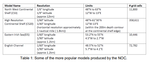
Once the model has been set up it can be run for any length of time to generate ‘virtual’ observations at many thousands of locations. The area being modelled is first divided up into a grid (using lines of latitude and longitude). If the average depth of each grid cell is known along with the tide at a set number of points (usually at the model boundary and maybe some coastal ports), the tidal movement of water over the area can be derived using Newtonian physics.
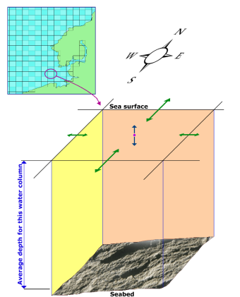
The result is a time series of sea level and current for each cell for the duration of the model run.
These are then usually compared to long period 'real' observations within the model area, and the model tuned and re-run if necessary. The finer the grid resolution, the more accurately the model will be able to resolve smaller-scale features, such as an eddy around a headland for example. However ocean modelling requires tremendous computing power. Even using the latest workstations and supercomputers, oceanographers have to limit the area of their finer-scale models otherwise model runs could take many weeks.
Single model runs can also generate huge amounts of data (a one year run of the English
Channel model storing only the hourly data generated about 16GB).