![NOCI logo.png]](https://knowledge-software.noc-innovations.com/hs-fs/hubfs/NOCI%20logo.png?height=50&name=NOCI%20logo.png)
Most locations around the world exhibit what are known as semidiurnal tides –
meaning there are on average two tidal cycles per day (two high tides and two
low tides). Most tide tables are designed on this basis and allow for 4 (or
occasionally 5) tides on any given day.
Some locations however may exhibit more unusual tidal behaviour such as additional turning points, ripples on the rising or falling tide or times in the year were the tide almost completely disappears.
These locations can be problematic for tide tables that aren't suitable in situations when there may be 6 or more tides on a day.
The graph below shows a typical spring tide at Southampton where 8 turning points can be seen in a 24 hour period (4 high waters marked with red dots, and 4 low waters marked with green dots).
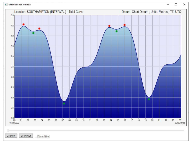
You can see that the four high waters all have a valid claim to be classed as high waters, however two of the low waters are just the minima turning point between the high waters. This is why Southampton is generally referred to as a double high-water port.
Some locations have even more complex tides that make it hard to identify if the port is a double high water or double low water.
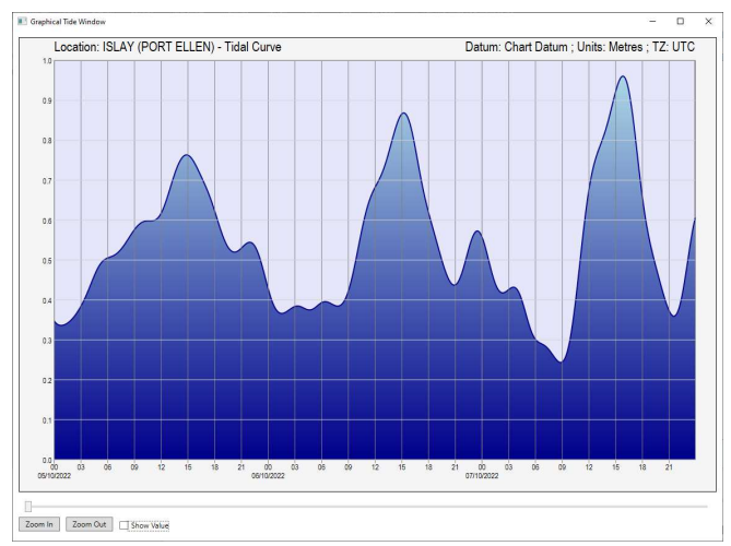
This tidal graph shows the tide at Islay (Port Ellen) over 3 days. Since the primary purpose of Poltips is the production of tide tables, picking out just 2 high waters and 2 low waters on each day is an important feature. The software must distinguish between the 'real' turning points and the secondary turning points such as ripples, or the 'low' waters that occur between a double high water.
Dealing with more than 4 tides per day
After computing the high and low waters for the requested time period, Poltips will count the number of tides on each day. If the maximum number on any day is four, then there will not be any issues with the standard tide table layouts.
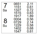
If there is a maximum of 5 on any one day, then Poltips will adjust the spacing of
the tide table to fit in the extra tide (see below).
On any day where there are more than 5 tides, the tide table won't be able to displaying all of them. Therefore the user will be informed, and asked if they want Poltips to attempt to identify the primary tides, and delete the secondary ones to bring the maximum on a day to 5 or less.
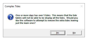
If the user clicks 'Yes', then the software will remove extra tides based on one of two algorithms.
- Identify if the tide is a double high water or double low water. If a double-HW, then retain the first HW, even if this is not the highest of the two. This creates better consistency in the timing of the high waters.
- Always retain the highest HW and the lowest LW in each tidal cycle. This may cause the tides to appear to jump around more erratically in time. The algorithm used is dependent on the location and is set by the NOC to best suit the location.
What happens to the removed tides?
When tides are removed by one of the two algorithms mentioned above, they are actually still left in the data, but flagged as tides that should not be shown on the tide tables. You can see these tides if you look at the graph of the turning points. Here's an example showing the high and low waters for Southampton. White dots represent what the software considers the primary tides, and the red dots are flagged as secondary tides and will not be shown on a tide table.
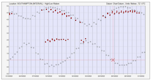
If you look at just one day, the double high water here occurs around midday, however there are other turning points that have also been removed. You can see those clearly when you look at the tidal curve by plotting the graph of the 5-minute predicted data (lower graph).
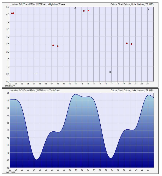
Poltips has correctly identified the first high water and removed the ripples on the rising tide, the 2ndhigh water, and the 'low water' between the two high waters, which has reduced the number of tides on that day from 12 down to 4 allowing it to be output in a traditional tide table layout.
There may be rare times when the software does not correctly identify the primary tide, or you
personally would prefer a different turning point be used on the tide table.
For tide manipulation in advanced mode see user guide page 39